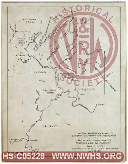
| Locator | Hist Soc - HS-C05228 | Type | Drawing | Doc Number | 11664-D | |
|---|---|---|---|---|---|---|
| Description | N&W Ry, Situation of Possible Coal Development in Mingo and Logan Counties, McDonald Land Co. Property | |||||
| Notes | Shows proposed Horsepen Creek Spur. | |||||
| Date | 04/15/1943 | Revision Date | ||||
| Author | N&W Rwy - Off. Asst Engr | Accession | 2009.001 : NS Corp/Va Tech Collection | |||

|
||
Size: 14in x 18in (35cm x 45cm) |
| Related | 11664-E | Hist Soc - HS-D10280 | Map showing Proposed Spur up Horsepen Creek in Mingo County, near Gilbert, WV. MP W7.43 Map covers area from Matewan to Wharncliffe & Gilbert |
| Related | 11664-C | Hist Soc - HS-C10155 | Guyandot & Tug River R.R. Co., Map of Tributary Territory, Mingo and Logan Counties WV Scale: 1"=7000', "From Richards Map", In pencil hows "Pro. Extn. to mate Cr. Br L=4.2 mi" |
| Related | 11664-J | Hist Soc - HS-E10155 | Map Showing Lines of N&W, C&O and VGN in the Vicinity of Gilbert, W.Va. and Proposed Extensions to serve US Coal and Coke Co. Scale 1"=3000' Never constructed |
| Related | 11660-E | Hist Soc - HS-U10031 | Gilbert Branch, Proposed Spur up Horsepen Creek to serve operation of the United States Steel Company, MP W7+2195.0' Spur would have been over 5 miles long (if it was ever built?) |
| Related | 11660 | Hist Soc - HS-U10035 | Guyandot & Tug River RR Co., Map of Location of Horsepen Creek Branch, from Mouth of Horsepen Creek to Shirkey Branch. Shows projected extensions of line to connect to Lenore Branch via Shirkey Branch to Island Creek (via 3550' tunnel), and either Nighway Branch (via 1850' tunnel) or Rockhouse Branch. Also shows proposed location of C&O extension up Horsepen Creek from Gilbert west up Horsepen Creek and then up Browning Fork. |
| Related | 11664-A | Hist Soc - HS-B24716 | Guyandot & Tug River, Map showing Proposed Horsepen Creek Branch, Mingo County, WV. |
| Related | 11664-B | Hist Soc - HS-B24717 | Guyandot & Tug River, Map showing Coal Properties in vicinity of Gilbert, Mingo County, WV. |