| Locator | Hist Soc - HS-B07124 | Type | Drawing | Doc Number | C-716 | |
|---|---|---|---|---|---|---|
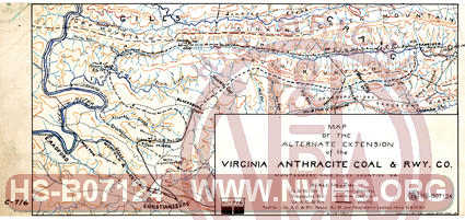
| Description | Map of Alternate Extension of Virginia Anthracite Coal & Railway Co, Montgomery & Giles Co. VA | |||||
| Notes | Shows 2 possible extensions from Blacksburg, VA to Francisco, VA in detail Also shows Virginian, N&W tracks at E. Radford & Christiansburg and geography (mountains and rivers) - interesting map |
|||||
| Date | 07/30/1905 | Revision Date | 06/12/1911 | |||
| Author | N&W Rwy - Kenova, WV | Accession | 2005.004 : Library of Virginia | |||

|
||
Size: 17in x 8in (43cm x 20cm) |
| Child | C-716 | Hist Soc - HS-B00876 | Map of the alternate extension of the Virginia Anthracite Coal & Rwy. Co. Montgomery and Giles County Va Scale 1" = 2 Mile. Shows N&W, VGN and Va. A. C. & Ry in different colors. Shows two routes from Blacksburg to Franciso, VA (on Craigs Creek) |
| Child | C-716 | Hist Soc - HS-B00877 | Map of the alternate extension of the Virginia Anthracite Coal & Rwy. Co. Montgomery and Giles County Va Scale 1" = 2 Mile. VGN not show on this drawing. Shows two routes from Blacksburg to Franciso, VA (on Craigs Creek) |
| City | Christiansburg - VA |
| City | Radford - VA |
| City | Blacksburg - VA |
| City | Montgomery - VA |
| City | Francisco - VA |
| City | Giles Co. - VA |
| Structure | Mine - Coal |
| Structure | River |
| Company | N&W Rwy - Norfolk & Western Railway |
| Company | VGN Rwy - Virginian Railway |
| Company | VAC&RY - Virginia Anthracite Coal & Railway |
| Division | N&W Rwy - Radford - Blacksburg Br |