| Locator | Hist Soc - HS-C01596 | Type | Drawing | Doc Number | Y-7114 | |
|---|---|---|---|---|---|---|
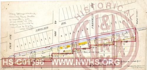
| Description | N&W Ry, Untitled Map of proposed exchange of lands for double tracking in Columbus. | |||||
| Notes | Scale 1.5"=1'. "Idea of Exchange abandoned account of track elevation for separation of grade at all streets, as all property we own will be required for Right of Way". |
|||||
| Date | 07/29/1907 | Revision Date | ||||
| Author | N&W Rwy - Portsmouth, OH | Accession | 2005.004 : Library of Virginia | |||

|
||
Size: 20in x 9in (50cm x 24cm) |
| Cities Indexes | |
|---|---|
| City | State |
| Columbus | OH |
| Structures Indexes | |
|---|---|
| Category | Type |
| Land | |
| Land | Lots |
| Railroads and Companies | |
|---|---|
| Abbreviation | Name |
| N&W Rwy | Norfolk & Western Railway |
| Division Indexes | |||
|---|---|---|---|
| Road Name | Division | District/Branch | Mile Post |
| N&W Rwy | Scioto | ||
| Related Documents | |||
|---|---|---|---|
| Type | Number | Locator | Description |
| Related | Y-7114A | Hist Soc - HS-CC00761 | N&W Ry, Plan Showing Property to be Conveyed by Ikes & Lane to N&W Ry. and N&W Ry. to Ikes & Lane between Bryden Road and Fair Ave, Franklin Park Place, Columbus OH, MP 701+3301.5' |
| Related | Y-7114C | Hist Soc - HS-CC00763 | N&W Ry,Map of Land to be Deeded to [Blank] between Bryden Road and Fair Ave, Franklin Park Place, Columbus OH, MP 701+3321.5' to MP 701+3989.4' |
| Related | Y-7114B | Hist Soc - HS-CC00762 | N&W Ry, Plan Showing Vacation & Dedication of Alleys & Streets, between Bryden Roand and Fair Ave, Franklin Park Place, Columbus OH, MP 701+3301.5' |