| Locator | Hist Soc - HS-A10125 | Type | Drawing | Doc Number | PH91 | |
|---|---|---|---|---|---|---|
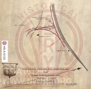
| Description | N&W RR, Radford Div., Plat of Land at Christiansburg to be purchased from Norvel Curtis, Area 0.438 acres. | |||||
| Notes | Scale 1"=200'. Plot between N&W main line and Crab Creek in Christiansburg, for connection with and beginning of the Kingston Branch. Shows a Signal Tower east of connection where main line went from single to three tracks. |
|||||
| Date | 01/02/1892 | Revision Date | ||||
| Author | N&W RR - Office of Chief Engr | Accession | 2009.001 : NS Corp/Va Tech Collection | |||

|
||
Size: 7in x 7in (19cm x 18cm) |
| Cities Indexes | |
|---|---|
| City | State |
| Christiansburg | VA |
| Cambria | VA |
| Structures Indexes | |
|---|---|
| Category | Type |
| Land | |
| Tower | Signal |
| Division Indexes | |||
|---|---|---|---|
| Road Name | Division | District/Branch | Mile Post |
| N&W RR | Radford | 289 | |
| N&W RR | Radford | Kingston Br | |
| Related Documents | |||
|---|---|---|---|
| Type | Number | Locator | Description |
| Parent | 3084 | Hist Soc - HS-W00342 | N&W RR, Map and Profile of Branch Line to Kingston Mine at Christiansburg, VA |
| Related | PH93 | Hist Soc - HS-B10708 | Plat of Land to be Purchased from Cambria Land & Improvement Co. |